


XII Geo First Semester Que Paper & Ans
XII Geography First Semester Question Paper & Answers
बारावी भूगोल प्रथमसत्र परीक्षा प्रश्नपत्रिका व तिची उत्तरपत्रिका
इयत्ता बारावी प्रथम सत्र परीक्षा
विषय : भूगोल
गुण : 50
वेळ : 2.30 तास
———————————————————————————————-
सूचना :
- सर्व प्रश्न सोडविणे आवश्यक आहे.
- प्रश्नांची उत्तरे लिहिताना आवश्यक तेथे योग्य आकृत्या / आलेख काढा.
- रंगीत पेन्सिलचा वापर करण्यास परवानगी आहे.
- योग्य तेथे नकाशा स्टेंसिलचा वापर करावा.
- उजवीकडील अंक पूर्ण गुण दर्शवितात.
- आलेख पुरवणी व नकाशा पुरवणी मूळ उत्तरपत्रिकेस जोडावी.
———————————————————————————
XII Geo First Semester Que Paper & Ans
XII Geography First Semester Question Paper & Answers
बारावी भूगोल प्रथमसत्र परीक्षा प्रश्नपत्रिका व तिची उत्तरपत्रिका
प्रश्न 1. दिलेल्या सूचनेनुसार उप-प्रश्न सोडवा : (13)
(अ) खालील साखळी पूर्ण करून लिहा : (4)
| अ | ब | क |
| अंटार्क्टिका खंड | कायम बर्फाच्छादित प्रदेश | कायम निवासी लोकसंख्या नाही |
| लाकूडतोड | समशीतोष्ण सूचीपर्णी वने | व्यापारी तत्त्वावर लाकूडतोड |
| सखोल उदरनिर्वाहक शेती | शेतीचा आकार लहान | तांदूळ हे प्रमुख पीक |
| साखर कारखाना | वजन घटणारा कच्चा माल | ऊस उत्पादक प्रदेश |
(ब) अचूक घटक ओळखा : (3)
1. लोकसंख्या संक्रमणातील खालीलपैकी कमी वाढ दर्शविणारा टप्पा कोणता?
अ) पहिला टप्पा
ब) तिसरा टप्पा
क) चौथा टप्पा
ड) पाचवा टप्पा
2. समुद्रकिनारी प्रदेशात आढळणारा आकारानुसार वस्ती प्रकार:
अ) आयताकृती वस्ती
ब) त्रिकोणी वस्ती
क) वर्तुळाकार वस्ती
ड) रेषीय वस्ती
3. टुंड्रा प्रदेशातील शिकार व्यवसाय करणारी जमात:
अ) एस्किमो
ब) पिग्मी
क) बोरा इंडियन
ड) सेंटीनल
(क) अचूक सहसंबंध ओळखा : (3)
1. A: सुपीक मैदानी प्रदेशात दाट लोकवस्ती आढळते.
R: सुपीक मृदा ही शेतीसाठी उपयुक्त असते.
अ) केवळ A बरोबर आहे.
ब) केवळ R बरोबर आहे.
क) A आणि R दोन्ही बरोबर आहेत आणि R हे A चे अचूक स्पष्टीकरण आहे.
ड) A आणि R दोन्ही बरोबर आहेत परंतु R हे A चे अचूक स्पष्टीकरण नाही.
2. A: नगरे वाढतात, त्याबरोबर त्यांची कार्येही वाढतात.
R: एका नगराला केवळ एकच कार्य असू शकते.
अ) केवळ A बरोबर आहे.
ब) केवळ R बरोबर आहे.
क) A आणि R दोन्ही बरोबर आहेत आणि R हे A चे अचूक स्पष्टीकरण आहे.
ड) A आणि R दोन्ही बरोबर आहेत परंतु R हे A चे अचूक स्पष्टीकरण नाही.
3. A: लोकसंख्या मनोऱ्यात रुंद तळ बालकांची संख्या अधिक असल्याचे दर्शवितो.
R: लोकसंख्या मनोऱ्याचे रुंद शीर्ष वृद्धांची संख्या अधिक असल्याचे द्योतक आहे.
अ) केवळ A बरोबर आहे.
ब) केवळ R बरोबर आहे.
क) A आणि R दोन्ही बरोबर आहेत आणि R हे A चे अचूक स्पष्टीकरण आहे.
ड) A आणि R दोन्ही बरोबर आहेत परंतु R हे A चे अचूक स्पष्टीकरण नाही.
(ड) दिलेल्या सूचनेनुसार विधाने पूर्ण करा : (3)
1. चढत्या वयोरचनेनुसार योग्य क्रम लावा
अ) प्रौढ
ब) बालक
क) वृद्ध
ड) युवा
2. लोकसंख्या लाभांशाची योग्य व्याख्या खालीलपैकी कोणत्या विधानात योग्य प्रकारे दर्शवली आहे?
अ) देशातील एकूण लोकसंख्येत बालकांची संख्या वाढणे.
ब) एखाद्या देशाच्या वयोरचनेत होणाऱ्या बदलामुळे त्याच्या अर्थव्यवस्थेत झालेली वाढ.
क) देशातील वृद्धांचे प्रमाण वाढून वैद्यकीय खर्च वाढणे.
ड) ग्रामीण भागातून शहरांकडे होणारे लोकसंख्येचे स्थलांतर.
3. विषुववृत्तीय प्रदेशापासून ध्रुवीय प्रदेशांकडे वनांचा क्रम लावा.
अ) उष्णकटिबंधीय पानझडी वने
ब) विषुववृत्तीय सदाहरित वने
क) समशीतोष्ण कटिबंधीय सूचीपर्णी वने
ड) समशीतोष्ण कटिबंधीय पानझडी वने
प्रश्न 2. भौगोलिक कारणे लिहा (कोणतेही दोन) : (6)
- नगरांची वाढ ही भूमी उपयोजनाशी निगडित आहे.
- स्थलांतर हे नेहमी कायमस्वरूपी असते असे नाही.
- कॅनडामध्ये लाकूडतोड व्यवसायाचा विकास झाला आहे.
प्रश्न 3. फरक स्पष्ट करा (कोणतेही दोन) : (6)
- स्थलांतराचे आकर्षक घटक आणि अपकर्षक घटक
- ओसाड भूमी आणि बिगरशेती भूमी
- केंद्रित वस्ती आणि विखुरलेली वस्ती
XII Geo First Semester Que Paper & Ans
XII Geography First Semester Question Paper & Answers
बारावी भूगोल प्रथमसत्र परीक्षा प्रश्नपत्रिका व तिची उत्तरपत्रिका
प्रश्न 4. (अ) जगाच्या नकाशा आराखड्यात खालील बाबी योग्य चिन्हांच्या व सूचीच्या सहाय्याने दाखवा (कोणतेही चार) : (4)
- ऑस्ट्रेलियातील वाळवंटी प्रदेश
- लोकसंख्या संक्रमण सिद्धांतातील पाचव्या टप्प्यातील देश (उदा. स्वीडन)
- डॉगर बँक मत्स्यक्षेत्र
- रॉकी पर्वतीय प्रदेश (उत्तर अमेरिकेतील भू-भाग)
- अरबी समुद्रातील खाणकाम क्षेत्र (मुंबई हाय)
प्रश्न 4. (ब) दिलेल्या आलेखाचे वाचन करून विचारलेल्या प्रश्नांची उत्तरे लिहा : (3)
1. आकृतीत जागतिक लोकसंख्या वितरणाची सर्वाधिक टक्केवारी कोणत्या खंडाची दर्शवली आहे?
2. सर्वांत कमी लोकसंख्या असलेला खंड कोणता?
3. आशिया खंडातील लोकसंख्या वितरणाची टक्केवारी किती आहे?
प्रश्न 5. टीपा लिहा (कोणतीही एक) : (4)
- लोकसंख्या संक्रमण सिद्धांताचा तिसरा टप्पा
- मासेमारी व्यवसायावर परिणाम करणारे घटक
प्रश्न 6. (अ) पुढील उताऱ्याचे वाचन करून त्याखाली विचारलेल्या प्रश्नांची उत्तरे लिहा : (4)
मानवाच्या अमर्याद व्यावसायिक लाभासाठी जगभरात सुरू असलेली बेसुमार लाकूडतोड आणि वन्यजीवांची अवैध शिकार यामुळे निसर्गाचा समतोल अक्षरशः धोक्यात आला आहे. जंगलांमधील मौल्यवान वृक्षांची कत्तल करून कागद व फर्निचर उद्योगासाठी लाकडाची तस्करी केली जात आहे, तर दुसरीकडे चामडे, दात व मांसासाठी मुक्या प्राण्यांची क्रूर शिकार सुरू आहे. या अनियंत्रित व्यवसायामुळे घनदाट अरण्ये नष्ट होऊन जागतिक तापमानवाढ आणि हवामान बदलाचा गंभीर धोका निर्माण झाला आहे. वन्यजीवांचे नैसर्गिक अधिवास उध्वस्त झाल्यामुळे अनेक दुर्मिळ प्रजाती नामशेष होण्याच्या मार्गावर आहेत. जंगले कमी झाल्याने मातीची धूप वाढणे आणि पर्जन्यमान चक्र बिघडल्यासारख्या नैसर्गिक आपत्तींना मानवाला तोंड द्यावे लागत आहे. या विनाशास कारणीभूत ठरणाऱ्या अवैध लाकूडतोड व शिकारीवर चाप लावण्यासाठी प्रशासनाने कठोर कायदे करून कडक अंमलबजावणी सुरु आहे परंतु अवैध मार्गाने लाकुडतोड व शिकार करणे अजून पूर्ण पणे थांबलेले नाही.
प्रश्न :
1) जागतिक लाकूडतोड आणि शिकारीमागे मानवाचा कोणता मुख्य उद्देश असतो?
2) अनियंत्रित लाकुडतोड व शिकारीमुळे पर्यावरण आणि वन्यजीवांवर कोणता विपरीत परिणाम झाला आहे?
3) परीछेदातील गंभीर समस्येवर नियंत्रण मिळवण्यासाठी काय करणे गरजेचे आहे?
4) लाकूडतोड व शिकारीच्या विनाशास कोणती गोष्ट मुख्यत्वे कारणीभूत ठरत आहे?
प्रश्न 6. (ब) खालीलपैकी एका घटकाची सुबक आकृती काढून नावे द्या : (2)
- वयोरचनेचा विस्तारणारा मनोरा
- रेषीय वस्ती
प्रश्न 7. खालीलपैकी कोणत्याही एका प्रश्नाचे सविस्तर उत्तर लिहा : (8)
- लोकसंख्या वितरणावर परिणाम करणारे प्राकृतिक घटक उदाहरणासह स्पष्ट करा.
- प्राथमिक आर्थिक क्रिया म्हणजे काय हे सांगून प्राथमिक आर्थिक क्रियेचे प्रकार स्पष्ट करा.
XII Geo First Semester Que Paper & Ans
XII Geography First Semester Question Paper & Answers
बारावी भूगोल प्रथमसत्र परीक्षा प्रश्नपत्रिका व तिची उत्तरपत्रिका
उत्तरपत्रिका
XII Geo First Semester Que Paper & Ans
XII Geography First Semester Question Paper & Answers
बारावी भूगोल प्रथमसत्र परीक्षा प्रश्नपत्रिका व तिची उत्तरपत्रिका
प्रश्न १. दिलेल्या सूचनेनुसार उप-प्रश्न सोडवा –
(अ) खालील साखळी पूर्ण करून लिहा –
| अ | ब | क |
| अंटार्क्टिका खंड | कायम बर्फाच्छादित प्रदेश | कायम निवासी लोकसंख्या नाही |
| लाकूडतोड | समशीतोष्ण सूचीपर्णी वने | व्यापारी तत्त्वावर लाकूडतोड |
| सखोल उदरनिर्वाहक शेती | शेतीचा आकार लहान | तांदूळ हे प्रमुख पीक |
| साखर कारखाना | वजन घटणारा कच्चा माल | ऊस उत्पादक प्रदेश |
(ब) अचूक घटक ओळखा –
- उत्तर- क) चौथा टप्पा
- उत्तर- ब) त्रिकोणी वस्ती
- उत्तर- अ) एस्किमो
(क) अचूक सहसंबंध ओळखा –
- उत्तर- क) A आणि R दोन्ही बरोबर आहेत आणि R हे A चे अचूक स्पष्टीकरण आहे.
- उत्तर- अ) केवळ A बरोबर आहे.
- उत्तर- ड) A आणि R दोन्ही बरोबर आहेत परंतु R हे A चे अचूक स्पष्टीकरण नाही.
(ड) दिलेल्या सूचनेनुसार विधाने पूर्ण करा –
- उत्तर- ब) बालक ड) युवा अ) प्रौढ क) वृद्ध
- उत्तर- ब) एखाद्या देशाच्या वयोरचनेत होणाऱ्या बदलामुळे त्याच्या अर्थव्यवस्थेत झालेली वाढ.
- उत्तर- ब) विषुववृत्तीय सदाहरित वने अ) उष्णकटिबंधीय पानझडी वने ड) समशीतोष्ण कटिबंधीय पानझडी वने क) समशीतोष्ण कटिबंधीय सूचीपर्णी वने
XII Geo First Semester Que Paper & Ans
XII Geography First Semester Question Paper & Answers
बारावी भूगोल प्रथमसत्र परीक्षा प्रश्नपत्रिका व तिची उत्तरपत्रिका
प्रश्न 2. भौगोलिक कारणे लिहा :
1. कारण-
① नागरी भागातील नागरीकीकरण, औदयोगिकरण, वाहतुकी सुविधांचा विकास, विविध व्यवसायांच्या, सेवा व सुविधांच्या विकासामुळे नगरांची वाढ होत असते.
② ज्या प्रमाणात नगराचा विकास होत जातो त्याप्रमाणात तेथील जमीनीचा वापर वाढत जातो.
③ नगरातील वाढत्या नागरीकरणामुळे निवासी क्षेत्रात मोठया प्रमाणात वाढ होते व जमीनीची मागणी वाढते.
④ औदयोगीक क्षेत्रातील वाढीमुळे औदयोगीक करणांच्या विविध घटकांसाठी भूमीउपयोजन वाढत जाते.
⑤ नगरातील वाहतूक सुविधांच्या वाढीमुळे रस्तेमार्ग, लोहमार्ग, मेट्रो, हवाई क्षेत्रातही भूमी उपयोजन वाढत जाते.
⑥ व्यापारी क्षेत्रातील वाढीमुळे व्यापारी संकुल व मॉलचे प्रमाण वाढत जाते
⑦ नगरांच्या वाढीमुळे वैद्यकीय व शैक्षणिक सुविधा तसेच खेळ व मंनोरजन सुविधांसाठी देखील भूमीचे उपयोजन वाढत जाते
अशाप्रकारे नगरांची वाढ ही भूमी उपयोजनाशी निगडित आहे.
2. कारण:
उत्तर- ① व्यक्ती किंवा व्यक्तींचा समुह जेव्हा एका स्थानाकडून दुसऱ्या स्थानाकडे एका राजकिय सीमेतुन दुसऱ्या राजकीय सीमेत, कमी किंवा जास्त कालावधीसाठी किंवा कायमस्वरुपी जाता तेव्हा या हालचालीस स्थलांतर असे म्हणतात.
② व्यक्ती नोकरीच्या संधी, उत्तम राहणीमान या सारख्या आकर्षक घटकांमुळे स्थलांतर करत असतो असे स्थलांतर बऱ्याच वेळा कायमस्वरुपी असते. अनेक वेळा व्यक्ती दुष्काळ, नैसर्गीक आपत्ती, युध्दजन्य परिस्थिती, सामाजिक असुरक्षितता, राजकीय असुरक्षितता या सारख्या कारणांमुळे देखिल स्थलांतर करीत असतो.
③ दुष्काळी परीस्थिती, युध्दजन्य परिस्थिती, नैसर्गीक आपत्तीत केलेले स्थलांतर परिस्थिती सुधारल्या नंतर व्यक्ती पुन्हा आपल्या मुळस्थानी परत येतो
④ आर्थिक कारणाने नोकरी निमित्त बाहेरगावी गेलेले अनेक लोकही निवृत्ती नंतर परत आपाल्यागावी येतात. ⑤ स्थलांतर हे विशिष्ट हेतु किंवा उद्दीष्टानुसार झाले असेल तर तो हेतू किंवा उद्दीष्ट साध्य झाल्यानंतर पुन्हा व्यक्ती मुळ ठिकाणी परत येतो
⑥ शैक्षणिक, पर्यटन, धार्मीक वैदयकीय कारणानांमुळे केलेल्या स्थलांतरात लोक पुन्हा आपल्या मुळ ठिकाणी परत येतात
⑥ सामाजिक व राजकीय कारणांमुळे केलेल्या स्थलांतरासुध्दा अनेक लोक परत मुळ ठिकाणी येतांना आढळून येते, म्हणजेच स्थलांतर हे नेहमीच कायमस्वरुप असते असे नाही.
3. कारण:
i) विस्तीर्ण सूचीपर्णी वने: कॅनडामध्ये समशीतोष्ण कटिबंधीय सूचीपर्णी (टॅगा) वनांचा विस्तृत प्रदेश पसरलेला आहे.
ii) एकाच जातीचे वृक्ष: या वनांमध्ये एकाच प्रकारच्या वृक्षांच्या जातींचे विस्तृत पट्टे एकत्र आढळतात, ज्यामुळे व्यापारी तत्त्वावर लाकूडतोड करणे अत्यंत सोपे व फायदेशीर ठरते.
iii) मऊ व उपयुक्त लाकूड: सूचीपर्णी वृक्षांचे लाकूड मऊ, हलके आणि वजनाने सोपे असते. या लाकडाचा वापर कागद, कागदाचा लगदा आणि विविध लाकडी वस्तू बनवण्यासाठी मोठ्या प्रमाणात होतो.
iv) यांत्रिकीकरणाचा वापर: कॅनडामध्ये झाडे तोडण्यासाठी आणि लाकडांची वाहतूक करण्यासाठी आधुनिक यंत्रे, करवती व प्रगत तंत्रज्ञानाचा वापर केला जातो.
v) जलवाहतुकीची सोय: हिवाळ्यात तोडलेली लाकडे बर्फाच्छादित नद्यांच्या पात्रात सोडून दिली जातात; उन्हाळ्यात बर्फ वितळल्यावर पाण्याच्या प्रवाहाबरोबर ही लाकडे सहज वाहून लाकूड कापण्याच्या गिरण्यांपर्यंत पोहोचतात.
XII Geo First Semester Que Paper & Ans
XII Geography First Semester Question Paper & Answers
बारावी भूगोल प्रथमसत्र परीक्षा प्रश्नपत्रिका व तिची उत्तरपत्रिका
प्रश्न 3. फरक स्पष्ट करा :
1.
| आकर्षक घटक | अपकर्षक घटक |
| 1) व्यक्तीकिंवा व्यक्तीसमुह एखादया क्षेत्राकडेकिंवा प्रदेशाकडे आकर्षिक होतात अशा कारणांना आकर्षक घटक म्हणतात. | 1) मानवाला मूळ वास्तव्याच्या स्थानापासुन दूर जाण्यास प्रवृत्त करणाऱ्या घटकांना अपकर्षक घटक म्हणतात. |
| 2) शिक्षण, रोजगाराच्या संधी, पायाभूत सुविधा, उच्च राहणीमान या सारखे घटक आकर्षक घटक म्हणून कार्य करत असतात. | 2) रोजगार कमी होणे, युध्द, दुष्काळ, पाण्याची कमतरता, सामाजिक ताण तणाव असे घटक अपकर्षक घटक म्हणून स्थलांतर घडवून आणतात. |
| 3) आकर्षक घटक ज्या प्रदेशात उपलब्ध असतात अशा प्रदेशाला घेणारा प्रदेश असेही म्हणतात. अशा प्रदेशात लोकसंख्या वाढत जाते व प्रदेशातील सोयीसुविधांवर ताण पडतो. | 3) अपकर्षक घटकामुळे प्रदेशातील लोक बाहेर पडतात. अशा प्रदेशास देणारा प्रदेश म्हणतात. तेथील लोकसंख्या कमी होते. अशा प्रदेशात सोयी सुविधांवर केलेला खर्च अनावश्यक ठरतो. |
| 4) अशा प्रदेशातील लिंग गुणोत्तरावर परिणाम होतो पुरुषांचे प्रमाण वाढते उदा. मुंबई | 4) रोजगारा साठी पुरुष बाहेर पडल्यामुळे अशा ठिकाणी स्त्रियांचे प्रमाण जास्त होते उदा. केरळ राज्य |
2.
| ओसाड भूमी | बिगरशेती भूमी |
| i) अर्थ: जी जमीन निसर्गात खडकाळ, घळीयुक्त किंवा वाळवंटी असून कोणत्याही तंत्रज्ञानाचा वापर करून शेतीखाली आणता येत नाही, तिला ओसाड भूमी म्हणतात. | i) अर्थ: जी जमीन शेतीव्यतिरिक्त इतर मानवी कारणांसाठी (उदा. घरे, उद्योग, रस्ते) वापरली जाते, तिला बिगरशेती भूमी म्हणतात. |
| ii) उपयोग व स्वरूप: ही जमीन शेती आणि मानवी वापरासाठी पूर्णपणे अनुत्पादक स्वरूपाची असते. | ii) उपयोग व स्वरूप: ही जमीन मानवी वस्त्या, कारखाने, रस्ते, दुकाने इत्यादींच्या उभारणीसाठी प्रत्यक्ष वापरात असते. |
| iii) बदलाची शक्यता: कोणत्याही आधुनिक तंत्रज्ञानाचा वापर केला तरी ही भूमी सहजासहजी शेतीयोग्य किंवा सुपीक बनवता येत नाही. | iii) बदलाची शक्यता: नागरीकरण आणि विकासाच्या गरजेनुसार शेतीयोग्य किंवा पडीक जमिनीचे रूपांतर बिगरशेती भूमीत सहज केले जाते. |
| iv) क्षेत्रातील बदल: नैसर्गिक परिस्थितीमुळे या भूमीच्या एकूण क्षेत्रात सहसा कोणताही मोठा बदल किंवा वाढ होत नाही. | iv) क्षेत्रातील बदल: औद्योगिकीकरण आणि शहरांचा विस्तार जसजसा वाढतो, तसतसे बिगरशेती भूमीचे क्षेत्र दिवसेंदिवस वाढत जाते. |
| v) उदाहरणे: उंचसखल पर्वतीय भाग, तीव्र उताराचे खडक, ओसाड वाळवंट, घळीयुक्त जमीन इत्यादी. | v) उदाहरणे: निवासी इमारती, रस्ते व लोहमार्ग, कारखाने, शाळा व महाविद्यालये इत्यादींनी व्यापलेली जमीन. |
3.
| केंद्रित वस्ती | विखुरलेली वस्ती |
| i) अर्थ: ज्या वस्तीमध्ये मानवी घरे एकमेकांशी अगदी जवळजवळ व दाट बांधलेली असतात, त्याला केंद्रित वस्ती म्हणतात. | i) अर्थ: ज्या वस्तीमध्ये मानवी घरे एकमेकांपासून दूर आणि विखुरलेल्या स्वरूपात असतात, त्याला विखुरलेली वस्ती म्हणतात. |
| ii) भौगोलिक परिस्थिती: सुपीक मैदानी प्रदेश, मुबलक पाणीपुरवठा व वाहतुकीच्या सोयी असलेल्या अनुकूल भागात केंद्रित वस्त्या आढळतात. | ii) भौगोलिक परिस्थिती: पर्वतीय, डोंगराळ प्रदेश, वाळवंट किंवा घनदाट वने अशा प्रतिकूल नैसर्गिक परिस्थितीच्या भागात विखुरलेल्या वस्त्या आढळतात. |
| iii) सामाजिक संबंध व सुविधा: केंद्रित वस्त्यांमध्ये लोकांचे सामाजिक संबंध दृढ असतात आणि आरोग्य, शिक्षण, वीज यांसारख्या सुविधा सहज उपलब्ध होतात. | iii) सामाजिक संबंध व सुविधा: घरांमध्ये अंतर जास्त असल्याने सामाजिक संपर्क मर्यादित असतो आणि पायाभूत सोयीसुविधांचा विकास कमी प्रमाणात होतो. |
| iv) लोकसंख्येची घनता: अशा वस्त्यांमध्ये मर्यादित क्षेत्रात लोकांचे केंद्रीकरण झाल्यामुळे लोकसंख्येची घनता जास्त असते. | iv) लोकसंख्येची घनता: अशा वस्त्यांमध्ये विस्तृत प्रदेशात कमी घरे असल्यामुळे लोकसंख्येची घनता अत्यंत कमी असते. |
| v) उदाहरणे: नदीची सुपीक खोरी (उदा. गंगेचे मैदान), मोठे रस्ते व रेल्वे जंक्शनचे भाग, किनाऱ्याचे मैदानी भाग इत्यादी. | v) उदाहरणे: हिमालयाचा पर्वतीय भाग, राजस्थानचे वाळवंट, मध्य भारतातील घनदाट जंगलांचे भाग इत्यादी. |
XII Geo First Semester Que Paper & Ans
XII Geography First Semester Question Paper & Answers
बारावी भूगोल प्रथमसत्र परीक्षा प्रश्नपत्रिका व तिची उत्तरपत्रिका
प्रश्न 4. (अ) जगाच्या नकाशा आराखड्यात खालील बाबी योग्य चिन्हांच्या व सूचीच्या सहाय्याने दाखवा (कोणतेही चार) : (4)
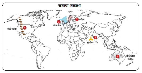

प्रश्न 4. (ब) दिलेल्या आलेखाचे वाचन करून विचारलेल्या प्रश्नांची उत्तरे लिहा : (3)
1) आकृतीत जागतिक लोकसंख्या वितरणाची सर्वाधिक टक्केवारी आशिया खंडाची (59.65%) दर्शवली आहे.
2) सर्वांत कमी लोकसंख्या असलेला खंड ऑस्ट्रेलिया (0.55%) हा आहे.
3) आशिया खंडातील लोकसंख्या वितरणाची टक्केवारी 59.65 % आहे.
XII Geo First Semester Que Paper & Ans
XII Geography First Semester Question Paper & Answers
बारावी भूगोल प्रथमसत्र परीक्षा प्रश्नपत्रिका व तिची उत्तरपत्रिका
प्रश्न 5. टीपा लिहा :
1. उत्तर-
① टप्प्याचे स्वरूप: या टप्प्याला ‘नंतरच्या काळात विस्तारणारा टप्पा’ असे म्हणतात.
② जन्मदरातील घट: समाजात शिक्षण आणि जनजागृती वाढल्यामुळे या टप्प्यात जन्मदर हळूहळू कमी होऊ लागतो.
③ मृत्यूदरातील नियंत्रण: उत्तम वैद्यकीय व आरोग्य सुविधांमुळे मृत्यूदर खूप कमी होतो आणि पूर्णपणे नियंत्रणात येतो.
④ लोकसंख्या वाढीचा वेग: या टप्प्यात जन्मदर हा मृत्यूदरापेक्षा जास्तच असतो, त्यामुळे एकूण लोकसंख्या वाढत राहते; परंतु लोकसंख्या वाढीचा वेग (दर) कमी होतो.
⑤ आर्थिक प्रगती व राहणीमान: देशाचा आर्थिक विकास झाल्यामुळे लोकांचे उत्पन्न वाढते, गरिबी कमी होते आणि राहणीमानाचा दर्जा उंचावतो.
⑥ व्यवसायांचा विस्तार: प्राथमिक व्यवसायांवरील (शेतीवरील) अवलंबित्व कमी होऊन द्वितीयक (उद्योग) आणि तृतीयक (सेवा) व्यवसायांचा मोठा विस्तार होतो.
⑦ कुटुंब नियोजन व प्रातिनिधिक देश: साक्षरता वाढल्याने लोकांना लहान कुटुंबाचे महत्त्व पटते. विकसनशील अवस्थेतून विकसित अवस्थेकडे वाटचाल करणारे देश (उदा. भारत, चीन) या टप्प्यात मोडतात.
2. उत्तर-
① उथळ समुद्र (भूखंड मंच): 200 मीटरपेक्षा कमी खोली असलेल्या भूखंड मंचावर सूर्यप्रकाश तळापर्यंत पोहोचतो; त्यामुळे माशांचे प्रमुख अन्न असणाऱ्या प्लवंगांची (Plankton) विपुल वाढ होते.
② उष्ण व थंड प्रवाहांचा संगम: जिथे उष्ण आणि थंड सागरी प्रवाह एकत्र येतात, तिथे प्लवंगांची भरपूर निर्मिती होऊन उत्तम नैसर्गिक मासेमारी क्षेत्रे तयार होतात (उदा. जपानजवळ कुरोशियो आणि ओयाशियो प्रवाह).
③ दंतूर किनारपट्टी: समुद्राची खाचखळग्यांची व दंतूर किनारपट्टी बोटी व जहाजे सुरक्षित ठेवण्यासाठी उत्तम नैसर्गिक बंदरांची निर्मिती करते.
④ थंड हवामान: थंड हवामानाच्या प्रदेशात मासे लवकर खराब होत नाहीत व सहज साठवता येतात; याउलट उष्ण प्रदेशात शीतगृहांची (Cold Storage) सोय करावी लागते.
⑤ वनसंपत्तीची उपलब्धता: किनाऱ्याजवळ सूचीपर्णी वने असल्यास बोटी व जहाजे बांधणीसाठी आवश्यक लाकूड सहज उपलब्ध होते.
⑥ अद्ययावत तंत्रज्ञान व मागणी: आधुनिक बोटी, राडार यंत्रणा, जाळी, शीतगृहे आणि माशांना असणारी प्रचंड जागतिक मागणी यांमुळे व्यापारी मासेमारीचा मोठा विकास होतो.
प्रश्न 6. (अ) उताऱ्यावरील प्रश्नांची उत्तरे
1. उत्तर: अमर्याद व्यावसायिक लाभ मिळवणे, कागद व फर्निचर उद्योगासाठी लाकडाची तस्करी करणे आणि चामडे, दात व मांसासाठी प्राण्यांची शिकार करणे हा यामागे मुख्य उद्देश असतो.
2. उत्तर: यामुळे घनदाट अरण्ये नष्ट होऊन जागतिक तापमानवाढ, हवामान बदल आणि अनेक दुर्मिळ वन्यजीव प्रजाती नामशेष होण्याचा धोका निर्माण झाला आहे.
3. उत्तर: या समस्येवर नियंत्रण मिळवण्यासाठी प्रशासनाने कठोर कायदे करून अवैध लाकूडतोड आणि शिकारीवर कडक अंमलबजावणी करणे गरजेचे आहे.
4. उत्तर: मानवाचा अमर्याद व्यावसायिक लाभ मिळवण्याचा उद्देश, कागद व फर्निचरसाठी लाकडाची तस्करी आणि प्राण्यांची क्रूर शिकार या विनाशास मुख्यत्वे कारणीभूत ठरत आहे.
XII Geo First Semester Que Paper & Ans
XII Geography First Semester Question Paper & Answers
बारावी भूगोल प्रथमसत्र परीक्षा प्रश्नपत्रिका व तिची उत्तरपत्रिका
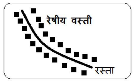
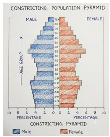
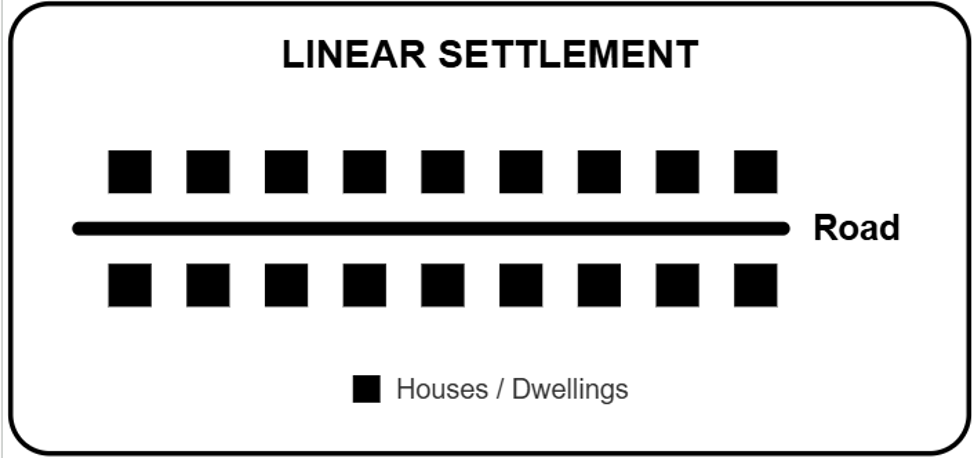
प्रश्न 6. (ब) खालीलपैकी एका घटकाची सुबक आकृती काढून नावे द्या : (2)
- वयोरचनेचा संकोचनारा मनोरा
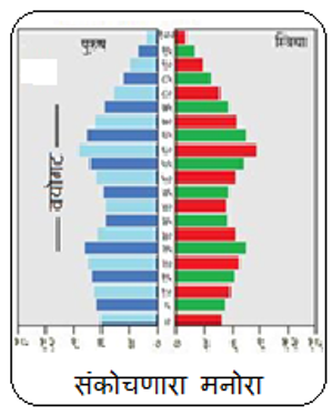
2 रेषीय वस्ती
XII Geo First Semester Que Paper & Ans
XII Geography First Semester Question Paper & Answers
बारावी भूगोल प्रथमसत्र परीक्षा प्रश्नपत्रिका व तिची उत्तरपत्रिका
प्रश्न 7 कोणत्याही एका प्रश्नाचे सविस्तर उत्तर लिहा- गुण 8
1) लोकसंख्येच्या वितरणावर परिणाम करणारे प्राकृतिक घटक उदाहरणासहित स्पष्ट करा.
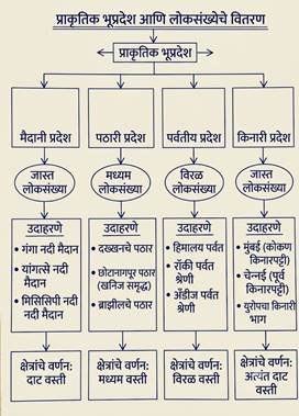
उत्तर- लोकसंख्या वितरणावर प्राकृतिक व मानवी घटकांचा परिणाम पहावयास मिळतो. जगात मानवी जीवनास पोषक व आरोग्यवर्धक हवामान असलेल्या ठिकाणी मानवी लोकसंख्या एकवटलेली आहे. त्यात विविध घटकांचा समावेश असतो. मानवी लोकसंख्या वितरणावर परिणाम करणारे घटक पुढील प्रमाणे-
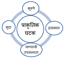
① प्राकृतिक रचना ( भूरुपे)–
अ) मैदाने / सुपिक खोरे- मैदानी प्रदेशात विपुल जलसंपत्ती मुळे व सुपीक मृदेमुळे शेती व्यवसाय विकसीत झालेला असतो त्यामुळे तेथे शेतीवर आधारीत व्यवसाय विकसीत होतात. रोजगाराच्या संधी अशा प्रदेशात जास्त असतात. त्याच बरोबर वाहतुक मार्गांच्या विकास, व उत्सावर्धक हवामान यामुळे मैदानी प्रदेशात लोकसंख्या जास्त असते.
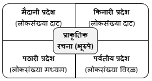
उदा. गंगा-सिंधू नदी मैदानी प्रदेश, यांगत्से व मिसिसिपी नदयांचे खोरे
ब) पठारी प्रदेश- पठारी प्रदेशात खनिज संपत्तीच्या उपलब्धतेमुळे खनिज संपत्तीवर आधारीत जड उदयोग विकसीत होतात तसेच काही भागात जलसिंचनाच्या सोयी उपलब्ध असलेल्या प्रदेशात शेतीस पुरक वातावरण असल्याने येथे मध्यम ते जास्त लोकसंख्या आढळते.
उदा. छोटा नागपुरचे पठार काही पठारांवर सुपिक मृदेमुळे लोकसंख्या जास्त आढळते.
क) पर्वतीय प्रदेश – पर्वतीय प्रदेशात उंची, पतिकूल हवामान, उतार, घनदाट अरण्ये, शेती अयोग्य जमीन यामुळे जिवन जगण्यास अनेक अडचणी असतात त्यामुळे पर्वतीय भागात लोकसंख्या विरळ आढळते. उदा. रॉकी, हिमालय अँडीज पर्वतांचे प्रदेश. काही ठिकाणी मात्र आवश्यक पाण्याची सोय, जीवन जगण्यासाठी आवश्यक व्यवस्था उपलब्ध असलेल्या पर्वतीय ठिकाणी काही प्रमाणात लोकसंख्या केंद्रीत झालेली आढळते.
उदा. पर्वतीय पर्यटन स्थळे
② हवामान– समशितोष्ण हवामान, भूमध्य सागरी हवामान, मोसमी हवामाना सारख्या अल्हाददायक हवामाच्या प्रदेशात जास्त लोकसंख्या आढळते उदा. युरोप खंडातील देश, आशिया खंडातील मौसमी हवामानाचा प्रदेश या उलट अति थंड, अति उष्ण, वाळवंटी प्रदेश, अति पर्जन्याचे प्रदेश हे मानवी वस्तीस अनुकूल नसतात त्यामुळे तेथे लोकसंख्या कमी असते. उदा. विषृववृत्तीय हवामान, वाळवंटी प्रदेश.
③ पाण्याची उपलब्धता– पाणी हा सर्व सजीवांसह मानवासाठीही महत्वाचा घटक आहे. पाणी मानवाच्या दैनंदिन गरजा पुर्ण करण्यासाठी आवश्यक असलेला व मोठया प्रमाणावर आवश्यक असलेला प्राकृतिक घटक असल्याने प्राचीण काळापासून मानवाने आपल्या वसाहती पाण्याच्या ठिकाणी वसविलेल्या आहेत. उदा. नाईल, गंगा इ. नदयांच्या खोऱ्यातील प्रदेश. तसेच समुद्रकिनारी प्रदेशात दाट लोकसंख्या आढळते. उदा. भारतीय किनारी प्रदेश. वाळवंटातील मरुदयाण्याच्या प्रदेशातही लोकसंख्या आढळते उदा. भारतातील फलोदी, सौदी अरेबियातील अल् अहसा इ.
④ मृदा– सुपीक गाळाच्या मृदेच्या प्रदेशात शेती व्यवसाय विकसतील होतो त्यामुळे तेथे इतर व्यवसांचा विकास होवुन लोकसंख्या अधिक असते. उदा. भारतातील गंगा नदी, मिसिसिपी, यांगत्से या नदयांची पुर मैदानांचा प्रदेश. त्याच बरोबर ज्वालामुखीय मृदेच्या सुपीकतेमुळे ही ज्वालामुखीय पर्वतांच्या पायथ्याच्या प्रदेशात शेती व्यवसाय विकसीत होतो व येथेही लोकसंख्या जास्त आढळते. उदा. जावा, जपान, सिसिली.
———
2. प्राथमिक आर्थिक क्रिया म्हणजे काय हे सांगून प्राथमिक आर्थिक क्रियेचे प्रकार स्पष्ट करा.
प्रस्तावना: ज्या मानवी आर्थिक क्रिया प्रत्यक्षपणे निसर्गावर आणि नैसर्गिक साधनसंपत्तीवर (जमीन, पाणी, वनस्पती, खनिजे, प्राणी) अवलंबून असतात, त्यांना ‘प्राथमिक आर्थिक क्रिया’ (Primary Economic Activities) असे म्हणतात या व्यवसायांतून मानवाला निसर्गाकडून थेट कच्चा माल प्राप्त होतो
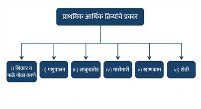
प्राथमिक आर्थिक क्रियेचे प्रमुख प्रकार :
i) शिकार करणे व फळे-कंदमुळे गोळा करणे
हा मानवाचा सर्वात प्राचीन व्यवसाय आहे यात वनातून फळे, कंदमुळे, पाने, औषधी वनस्पती, मध, डिंक, राळ, मेण गोळा केले जाते तसेच अन्नासाठी प्राण्यांची शिकार केली जाते. हा व्यवसाय पूर्णपणे निसर्गावर आधारित असून यात भांडवलाची गरज नसते.
उदा. विषुववृत्तीय वर्षावनातील पिग्मी व बोरा इंडियन जमाती; टुंड्रा प्रदेशातील एस्किमो जमात
ii) पशुपालन
नैसर्गिक गवताळ प्रदेशात प्राण्यांचे संगोपन करून दूध, मांस, लोकर, कातडी इत्यादी उत्पादने मिळवली जातात यात भटकंती पशुपालन (पारंपारिक) आणि व्यापारी पशुपालन (आधुनिक तंत्रज्ञानावर आधारित) असे दोन प्रकार पडतात
उदा. दक्षिण अमेरिकेतील पंपाज गवताळ प्रदेश, उत्तर अमेरिका व ऑस्ट्रेलियातील व्यापारी पशुपालन क्षेत्रे
iii) लाकूडतोड व्यवसाय
वनांमधील वृक्षांपासून लाकूड, कागदाचा लगदा, बांधकाम साहित्य व इंधन मिळवण्यासाठी लाकूडतोड केली जाते समशीतोष्ण कटिबंधीय सूचीपर्णी तैगा वनांमध्ये एकाच जातीचे वृक्ष विस्तृत प्रदेशात एकत्र आढळत असल्याने तेथे व्यापारी लाकूडतोड मोठ्या प्रमाणावर चालते उदा कॅनडा, रशिया आणि उत्तर युरोप मधील सूचीपर्णी वनांचा प्रदेश
iv) मासेमारी व्यवसाय
नद्या, तलाव आणि महासागरामधून मासे पकडण्याचा हा महत्त्वपूर्ण प्राथमिक व्यवसाय आहे उथळ समुद्र (भूखंड मंच), दंतूर किनारे आणि उष्ण व थंड सागरी प्रवाहांच्या संगमावर प्लवंगांची निर्मिती होऊन तेथे व्यापारी मासेमारी विकसित होते
उदा. वायव्य अटलांटिक महासागरातील ग्रँड बँक, जपानजवळील कुरोशियो आणि ओयाशियो प्रवाहांचा संगम प्रदेश
v) खाणकाम व्यवसाय
भूगर्भातील नैसर्गिक खनिज संपत्ती (धातू, अधातू, खनिज तेल, दगडी कोळसा) बाहेर काढण्याच्या क्रियेला खाणकाम म्हणतात. हा व्यवसाय संपूर्णपणे खनिजांच्या नैसर्गिक भूगर्भातील उपलब्धतेवर अवलंबून असतो
उदा. भारतातील छोटा नागपूर पठार (लोहखनिज व कोळसा); दक्षिण आफ्रिकेतील विटवॉटर्सरँड (सोने व हिरे)
vi) शेती व्यवसाय
प्राथमिक क्रियांमधील सर्वात व्यापक आणि मानवी अन्नधान्याची गरज भागवणारा प्रमुख व्यवसाय म्हणजे शेती होय जमिनीचा आकार, हवामान व तंत्रज्ञानानुसार शेतीचे विविध प्रकार पडतात:
- सखोल उदरनिर्वाहक शेती: (उदा. भारत, चीन, आशियातील तांदूळ उत्पादक प्रदेश)
- विस्तृत व्यापारी धान्य शेती: (उदा. प्रेअरी व स्टेप्स गवताळ प्रदेशातील गव्हाची शेती)
- मळ्याची शेती: (उदा. चहा, कॉफी, रबर, उसाचे मळे)
- मंडई बागायती शेती: (उदा. शहरांलगत फळे व भाजीपाला उत्पादन)
XII Geo First Semester Que Paper & Ans
XII Geography First Semester Question Paper & Answers
बारावी भूगोल प्रथमसत्र परीक्षा प्रश्नपत्रिका व तिची उत्तरपत्रिका
वरील उत्तरपत्रिकेत अपेक्षीत उत्तरे देण्यात आली असली तरी, ही उत्तरपत्रिका केवळ एक शैक्षणिक साहीत्य आहे. त्यात काही चुक अथवा तृंटी असल्यास बोर्डा कडून प्रदर्शीत करण्यात आलेली ऊत्तरपत्रिका अंतिम असेल.

अधिक वाचा –
HSC March 2026 Geography Question Paper and Answers
HSC 2021 Geography Question Paper and Answers
HSC बोर्ड जुलै 2024 भूगोल प्रश्नपत्रिका व तिची सोडविलेली उत्तरपत्रिका
HSC बोर्ड 2022 भूगोल प्रश्नपत्रिका व तिची उत्तरपत्रिका
बारावी भूगोल संपूर्ण अभ्यासक्रमावर आधारित योग्य पर्याय निवडा प्रश्न व त्यांची उत्तरे
बारावी भूगोल संपूर्ण अभ्यासक्रमावर आधारित साखळी
बारावी भूगोल युनिट टेस्ट 1- 25 मार्क्स
बारावी भूगोल प्रात्यक्षिक जर्नल
बारावी भूगोल प्रात्यक्षिक जर्नल साठी संपर्क करा
प्रा मनोज देशमुख 9607371951
बारावी भूगोलाची प्रश्नपत्रिका डाऊनलोड करा
English Medium Question Paper
Instructions:
- All questions are compulsory.
- Draw neat diagrams / graphs wherever necessary while answering questions.
- Use of coloured pencils is allowed.
- Use of map stencil is allowed wherever necessary.
- Figures to the right indicate full marks.
- Tie the graph supplement and map supplement to the main answer sheet.
Q. 1. Solve the sub-questions as per the instructions given: (13)
(A) Complete the chain and rewrite: (4)
| A | B | C |
| Continent of Antarctica | Permanently snow-covered region | No permanent human settlements |
| Lumbering | Temperate coniferous forest | Commercial lumbering |
| Intensive subsistence agriculture | Small size of farm | Rice is the major crop |
| Sugar factory | Sugarcane producing region | Weight-losing raw material |
(B) Identify the correct factor / component: (3)
1. Which of the following stages of Demographic Transition shows low growth?
A) First stage
B) Third stage
C) Fourth stage
D) Fifth stage
2. Which pattern of settlement is found in coastal areas based on shape?
A) Rectangular pattern
B) Triangular pattern
C) Circular pattern
D) Linear pattern
3. The hunting tribe living in the Tundra region:
A) Eskimo
B) Pygmy
C) Bora Indian
D) Sentinelese
(C) Identify the correct correlation: (3)
1. A: Densely populated areas are found in fertile plains.
R: Fertile soil is suitable for agriculture.
A) Only A is correct.
B) Only R is correct.
C) Both A and R are correct and R is the correct explanation of A.
D) Both A and R are correct but R is not the correct explanation of A.
2. A: As cities grow, their functions also increase.
R: A city can have only one single function.
A) Only A is correct.
B) Only R is correct.
C) Both A and R are correct and R is the correct explanation of A.
D) Both A and R are correct but R is not the correct explanation of A.
3. A: A broad base in a population pyramid indicates a high number of children.
R: A broad apex of a population pyramid is an indicator of a high number of elderly people.
A) Only A is correct.
B) Only R is correct.
C) Both A and R are correct and R is the correct explanation of A.
D) Both A and R are correct but R is not the correct explanation of A.
(D) Complete the statements as per given instructions: (3)
1. Arrange in correct ascending order of age structure:
A) Adults
B) Children
C) Elderly / Old
D) Youth
2. Which of the following statements correctly represents the definition of demographic dividend?
A) Increase in the number of children in the total population of the country.
B) Growth in the economy of a country as a result of a change in its age structure.
C) Increase in medical expenditure due to an increase in the proportion of elderly in the country.
D) Migration of population from rural to urban areas.
3. Arrange the forests in order from Equatorial region towards Polar region:
A) Tropical deciduous forests
B) Equatorial evergreen forests
C) Temperate coniferous forests
D) Temperate deciduous forests
Q. 2. Give geographical reasons (Any two): (6)
- Growth of urban settlements is related to land use.
- Migration is not always permanent.
- Lumbering activity has developed in Canada.
Q. 3. Distinguish between (Any two): (6)
- Pull factors and Push factors of migration
- Land use and Land cover
Q. 4. (A) Mark and name the following on the outline map of the world with suitable signs and index (Any four): (4)
- Desert region in Australia
- A country in Stage 5 of Demographic Transition Theory (e.g., Sweden)
- Dogger Bank fishing ground
- Rocky Mountain region (North American landmass)
- Mining area in the Arabian Sea (Mumbai High)
Q. 4. (B) Read the given graph and answer the questions that follow: (3)
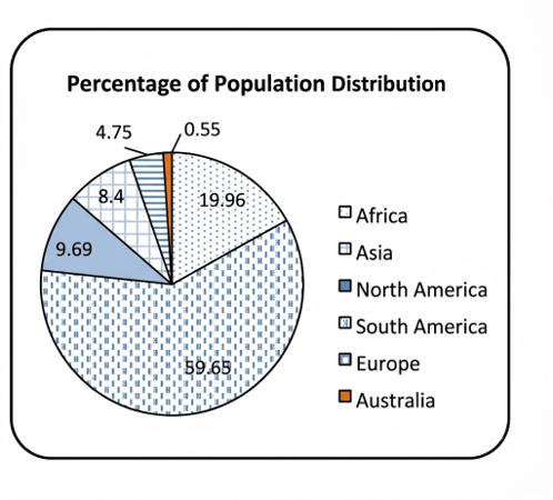
- Which continent shows the highest percentage of world population distribution in the figure?
- Which continent has the lowest population?
- What is the percentage of population distribution of the Asian continent?
Q. 5. Write short notes (Any one): (4)
- Stage 3 of Demographic Transition Theory
- Factors affecting fishing activity
Q. 6. (A) Read the following passage and answer the questions asked below: (4)
Due to unlimited commercial gains of human beings, reckless deforestation and illegal hunting of wild animals carried out all over the world has literally put the balance of nature in danger. Valuable trees in forests are being felled and wood is being smuggled for paper and furniture industries, while on the other hand, cruel hunting of voiceless animals is going on for leather, ivory/teeth, and meat. Due to these uncontrolled activities, dense forests are being destroyed, creating serious threats of global warming and climate change. Because natural habitats of wildlife have been devastated, many rare species are on the verge of extinction. Due to the decrease in forests, humans are facing natural disasters such as increasing soil erosion and disturbance in the rainfall cycle. To curb the illegal logging and hunting responsible for this destruction, the administration has framed strict laws and stringent implementation is underway, but illegal cutting of trees and poaching have not yet completely stopped.
Questions:
- What is the main objective of humans behind worldwide deforestation and hunting?
- What adverse impact has uncontrolled deforestation and hunting caused on the environment and wildlife?
- What is necessary to be done to control the serious problem mentioned in the passage?
- Which factor is mainly responsible for the destruction caused by deforestation and hunting?
Q. 6. (B) Draw a neat diagram of any one of the following and label it: (2)
- Expanding pyramid of age structure
- Linear settlement
Q. 7. Answer any one of the following questions in detail: (8)
- Explain with examples the physical factors affecting the distribution of population.
- What are primary economic activities? Explain the types of primary economic activities.
English Ansersheet
ANSWER KEY
Std: XII First Semester Examination
Subject: Geography
Q. 1. Complete the sub-questions as per the instructions given below:
(A) Complete the chain:
| A | B | C |
| Antarctica Continent | Permanently snow-covered region | No permanent human settlement |
| Lumbering | Temperate coniferous forest | Commercial lumbering |
| Intensive subsistence agriculture | Small size of farm | Rice is the major crop |
| Sugar industry | Weight-losing raw material | Sugarcane producing region |
(B) Identify the correct factor / component:
- Answer: (c) Fourth stage (Note: In low growth stages, both Stage 1 and Stage 4 have low growth; as per key: (c) Fourth stage)
- Answer: (d) Linear settlement
- Answer: (a) Eskimos
(C) Identify the correct correlation:
- Answer: (c) Both A and R are correct and R is the correct explanation of A.
- Answer: (a) Only A is correct.
- Answer: (d) Both A and R are correct, but R is not the correct explanation of A.
(D) Complete the statements as per instructions given:
- Answer: (b) Children
(d) Youth
(a) Adults
(c) Old / Aged
- Answer: (b) Growth in an economy as a result of a change in the age structure of a country’s population.
- Answer: (b) Equatorial evergreen forests
(a) Tropical deciduous forests
(d) Temperate deciduous forests
(c) Temperate coniferous forests
Q. 2. Give geographical reasons:
1. The growth of cities is related to land use.
Reason:
① Cities grow due to urbanization, industrialization, expansion of transport facilities, and the development of various occupations, services, and amenities in urban areas.
② As a city expands, the demand and utilization of its available land increase proportionally.
③ Rapid urban growth leads to a massive expansion in residential zones, increasing the demand for land.
④ Industrial development requires land allocation for factories, manufacturing units, and related infrastructure.
⑤ Expansion of transport networks requires land use for roads, railways, metro corridors, and airports.
⑥ Growth in commercial activities leads to an increase in shopping complexes, business centers, and malls.
⑦ With city growth, land is increasingly utilized for public utilities such as medical, educational, recreational, and sports facilities.
Thus, the growth of cities is closely linked to land use.
2. Migration is not always permanent.
Reason:
① Migration refers to the movement of a person or a group of persons from one place to another, across administrative or political boundaries, for a short period, long period, or permanently.
② People often migrate due to pull factors like better employment opportunities and higher living standards, which can frequently be permanent. However, migration also occurs due to push factors like droughts, natural disasters, wars, social unrest, or political instability.
③ People who migrate due to famines, wars, or natural hazards often return to their native places once conditions become normal.
④ Many individuals who migrate to urban centers for work or jobs return to their hometowns after retirement.
⑤ When migration occurs for a specific temporary purpose or goal, people return to their original place once that goal is accomplished.
⑥ Migration undertaken for education, tourism, pilgrimage, or medical treatment is temporary, and people return home after its completion.
⑦ Even in migrations driven by social and political reasons, people often move back when stability returns; therefore, migration is not always permanent.
3. Lumbering is developed in Canada.
Reason:
i) Vast Coniferous Forests: Canada has vast expanses of temperate coniferous (Taiga) forests.
ii) Monoculture / Pure Stands: These forests contain pure stands of single tree species over extensive areas, making commercial exploitation easy and economical.
iii) Soft and Useful Wood: The wood of coniferous trees is soft, light in weight, and easy to transport. It is extensively used as raw material for paper, pulp, and woodcrafts.
iv) Use of Mechanization: Modern machines, power saws, and advanced technology are widely used in Canada for felling trees and handling logs.
v) Water Transportation: Cut logs are left on frozen rivers during winter; when the snow melts in summer, the logs float down the river currents directly to the sawmills.
Q. 3. Differentiate between:
1. Pull factors and Push factors of migration
| Pull Factors | Push Factors |
| 1) The factors that attract people or groups towards a specific area or region are called pull factors. | 1) The factors that compel people to leave their native place of residence are called push factors. |
| 2) Factors like higher education, employment opportunities, modern infrastructure, and higher living standards act as pull factors. | 2) Factors like unemployment, wars, droughts, water scarcity, and social tensions act as push factors causing migration. |
| 3) A region with pull factors is called a ‘receiving region’. The population increases here, putting pressure on civic amenities. | 3) Due to push factors, people move out; such an area is called a ‘sending region’. The population decreases, and expenditure on infrastructure may become underutilized. |
| 4) The sex ratio of such regions is impacted, with an increase in the proportion of males (e.g., Mumbai). | 4) As men migrate outward for work, the proportion of females becomes higher in sending areas (e.g., State of Kerala). |
2. Barren / Wasteland and Non-agricultural land
| Barren / Wasteland | Non-agricultural Land |
| i) Meaning: Land that is naturally rocky, ravined, or desert and cannot be brought under cultivation with available technology is called barren or wasteland. | i) Meaning: Land used for human purposes other than agriculture (such as settlements, industries, roads) is called non-agricultural land. |
| ii) Use and Nature: This land is completely unproductive for agriculture and general human settlement. | ii) Use and Nature: This land is actively used for setting up human settlements, factories, roads, commercial shops, etc. |
| iii) Possibility of Change: Even with modern technology, this land cannot easily be converted into fertile agricultural land. | iii) Possibility of Change: Agricultural or fallow land can be easily converted into non-agricultural land based on the needs of urbanization. |
| iv) Change in Area: Due to natural constraints, the total area under barren land generally does not undergo significant change. | iv) Change in Area: As industrialization and urban expansion grow, the area under non-agricultural land keeps increasing over time. |
| v) Examples: Rugged mountainous terrains, steep rocky cliffs, arid deserts, gullied lands, etc. | v) Examples: Land occupied by residential buildings, roads, railways, factories, schools, colleges, etc. |
3. Nucleated settlement and Dispersed settlement
| Nucleated Settlement | Dispersed Settlement |
| i) Meaning: Settlements where human dwellings are built very close and compact to one another are called nucleated settlements. | i) Meaning: Settlements where human dwellings are scattered and located far apart from one another are called dispersed settlements. |
| ii) Geographical Conditions: Found in favourable environments like fertile plains, regions with abundant water supply, and well-connected transport routes. | ii) Geographical Conditions: Found in adverse environments like mountains, hilly tracts, deserts, or dense forests. |
| iii) Social Relations & Amenities: People have close social interaction, and civic amenities like health, education, and electricity are easily accessible. | iii) Social Relations & Amenities: Due to physical distances between houses, social interaction is limited and development of civic infrastructure is low. |
| iv) Population Density: Population density is high due to the concentration of people in a compact area. | iv) Population Density: Population density is very low as fewer houses are spread over vast geographic areas. |
| v) Examples: Fertile river valleys (e.g., Ganga plain), major road and railway junctions, coastal plains. | v) Examples: High Himalayan ranges, Thar desert of Rajasthan, dense forest areas of Central India. |
Q. 4. (A) Map Filling (World Outline Map):
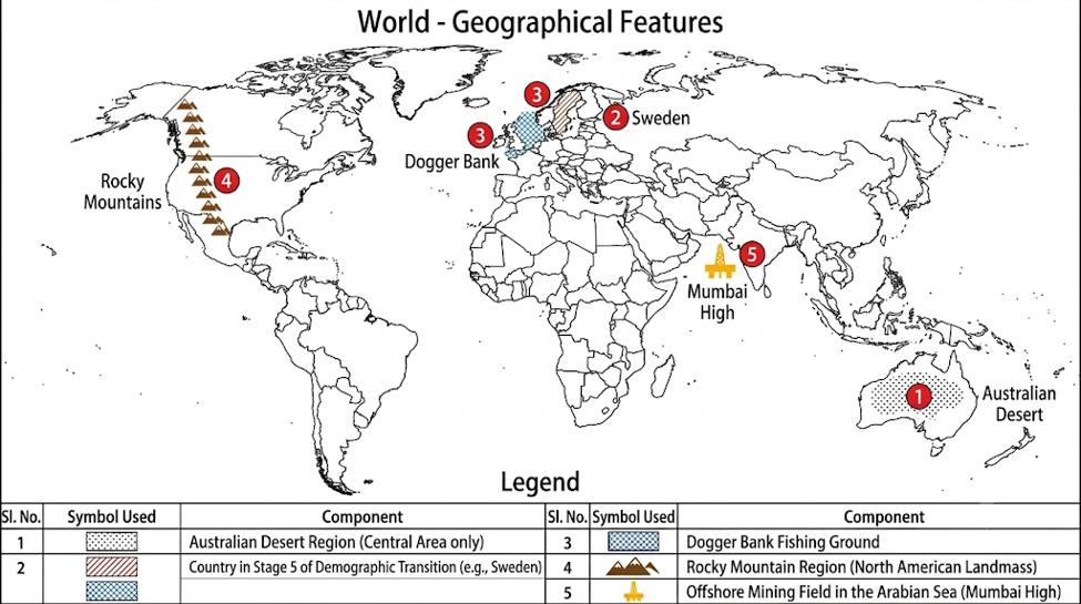
(Text elements and labels for Map & Legend)
(B) Graph Reading:
- In the figure, Asia has the highest percentage of global population distribution (59.65%).
- The continent with the least population is Australia (0.55%).
- The percentage of population distribution in the continent of Asia is 59.65%.
Q. 5. Write short notes:
1. Stage 3 of Demographic Transition Theory
① Nature of the Stage: This stage is known as the ‘Late Expanding Stage’.
② Decline in Birth Rate: With increasing education and awareness in society, the birth rate begins to decline gradually.
③ Controlled Death Rate: Due to improved medical and healthcare facilities, the death rate drops considerably and remains under control.
④ Rate of Population Growth: In this stage, the birth rate remains higher than the death rate, so the total population continues to grow, but the rate of growth slows down.
⑤ Economic Progress & Living Standards: Economic development leads to higher incomes, reduced poverty, and improved standard of living.
⑥ Expansion of Occupations: Dependence on primary occupations (agriculture) decreases, while secondary (industries) and tertiary (services) activities expand rapidly.
⑦ Family Planning & Representative Countries: Literacy encourages people to accept family planning and small family norms. Developing countries transitioning towards developed status (e.g., India, China) fall in this stage.
2. Factors affecting fishing activity
① Shallow Continental Shelf: On continental shelves with depths of less than 200 meters, sunlight reaches the seabed, supporting rich growth of plankton (the primary food for fish).
② Confluence of Warm and Cold Ocean Currents: Regions where warm and cold ocean currents meet promote immense growth of plankton, developing into rich commercial fishing banks (e.g., meeting of Kuroshio and Oyashio currents near Japan).
③ Broken / Indented Coastline: Indented and broken coastlines provide natural shelter and ideal conditions for the development of natural harbours and ports.
④ Cool Climate: In cold climates, fish remain preserved for longer durations without spoiling quickly, whereas tropical regions require cold storage facilities.
⑤ Availability of Forests: The presence of coniferous forests near coastal areas provides timber for building boats and fishing vessels.
⑥ Modern Technology & Demand: Modern mechanised trawlers, radar systems, refrigeration, cold storages, and large global market demand foster commercial fishing.
Q. 6. (A) Answers based on the passage:
- Answer: The main objective behind this is to gain unlimited commercial profit, smuggle timber for paper and furniture industries, and obtain skin, teeth/ivory, and meat through animal hunting.
- Answer: It has led to the destruction of dense forests, caused global warming and climate change, and pushed several rare wildlife species to the verge of extinction.
- Answer: To control this problem, the administration must formulate stringent laws and implement strict enforcement against illegal logging and poaching.
- Answer: Man’s uncontrolled greed for commercial profits, smuggling of wood for paper and furniture, and ruthless animal hunting are primarily responsible for this destruction.
(B) Diagrams:
1) Constricting Population Pyramid
2) Linear Settlement (along a road)
Q. 7. Answer any one of the following questions in detail:
1. Explain the physical factors affecting the distribution of population with examples.
Answer:
Population distribution is influenced by both physical and human factors. Globally, human population is concentrated in regions that have favorable and healthy climates for living. The key physical factors influencing the distribution of human population are as follows:
① Physiography (Relief):
- Plains / Fertile Valleys: Due to abundant water supply and fertile soils, agriculture flourishes in plain areas, spurring agro-based industries and employment. Good transport connectivity and pleasant climate lead to dense population. Examples: Ganga-Indus plains, Yangtze plain, and Mississippi river basin.
- Plateaus: Due to the availability of mineral deposits, heavy mineral-based industries develop in plateau regions. In areas with irrigation, agriculture also supports medium to high population density. Examples: Chota Nagpur Plateau; Deccan Plateau.
- Mountainous Regions: High altitude, harsh climate, steep slopes, dense forests, and lack of cultivable land create severe living difficulties, resulting in sparse population. Examples: Rocky, Himalayan, and Andes mountain ranges. However, some mountainous areas with scenic beauty and water supply develop as tourist hubs, supporting moderate clusters.
② Climate:
Regions with temperate, Mediterranean, or monsoon climates that are pleasant and comfortable support dense populations (e.g., countries in Western Europe, monsoon regions of Asia). Conversely, extreme climates like hyper-arid deserts, polar freezing regions, or hot and humid equatorial areas are inhospitable, resulting in sparse population (e.g., Equatorial rainforests, Sahara desert).
③ Availability of Water:
Water is essential for life and human activities. Since ancient times, human civilizations and settlements have sprung up along river valleys and water sources. Examples: Nile and Ganga river valleys. Coastal regions also support high population density. Even in deserts, settlements emerge around oases (e.g., Phalodi in India, Al-Ahsa in Saudi Arabia).
④ Soils:
Fertile alluvial soils foster extensive agriculture and related economic activities, supporting dense populations. Examples: Floodplains of Ganga, Mississippi, and Yangtze rivers. Similarly, fertile volcanic soils along volcanic slopes support intensive farming and high population density (e.g., Java, Japan, Sicily).
2. What are primary economic activities? Explain the types of primary economic activities.
Answer:
Introduction: Human economic activities that directly depend on nature and natural resources (such as land, water, vegetation, minerals, and animals) are called Primary Economic Activities. Through these activities, humans obtain raw materials directly from nature.
Major Types of Primary Economic Activities:
i) Hunting and Gathering:
This is the oldest economic activity of humans. It involves gathering fruits, roots, leaves, medicinal herbs, honey, gum, resin, and wax from forests, as well as hunting wild animals for food. It is completely nature-dependent and requires minimal capital.
Examples: Pygmies and Bora Indians in Equatorial rainforests; Eskimos in the Tundra region.
ii) Animal Husbandry (Pastoralism):
Involves rearing animals in natural grasslands to obtain milk, meat, wool, and hides. It is classified into nomadic pastoralism (traditional) and commercial livestock rearing (modern and technology-based).
Examples: Pampas grasslands of South America; commercial ranching in North America and Australia.
iii) Lumbering:
Involves felling trees in forests to obtain timber, wood pulp, construction material, and fuel. Commercial lumbering is highly developed in the temperate coniferous (Taiga) forests where pure stands of single tree species exist over extensive areas.
Examples: Coniferous forest regions of Canada, Russia, and Northern Europe.
iv) Fishing:
An important primary activity of catching fish from rivers, lakes, and oceans. Commercial fishing develops mainly around shallow continental shelves, broken coastlines, and regions where warm and cold ocean currents meet to produce plankton.
Examples: Grand Banks in the North-West Atlantic Ocean; confluence of Kuroshio and Oyashio currents near Japan.
v) Mining:
The process of extracting valuable mineral resources (metals, non-metals, mineral oil, coal) from beneath the earth’s surface is called mining. It depends completely on the geological occurrence and availability of minerals.
Examples: Chota Nagpur Plateau in India (iron ore and coal); Witwatersrand in South Africa (gold and diamonds).
vi) Agriculture:
The most widespread primary activity that fulfills human food requirements is agriculture. Depending on farm size, climate, and technology, agriculture has several types:
- Intensive Subsistence Agriculture: (e.g., Rice-dominated regions of India, China, and Monsoon Asia)
- Extensive Commercial Grain Farming: (e.g., Wheat cultivation in Prairies and Steppes grasslands)
- Plantation Agriculture: (e.g., Tea, coffee, rubber, and sugarcane plantations)
- Market Gardening / Horticulture: (e.g., Cultivation of fruits and vegetables near urban areas)
Downlaod English Med. Question paper 2026 (first Tearm)
ही पोस्ट तयार करताना विविध AI साधनांचा वापर करण्यात आलेला आहे

