
XI Geography Unit Test 1
अकरावी भूगोल प्रथम घटक चाचणी
प्रश्नपत्रिका
इयत्ता : 11 वी
विषय : भूगोल
वेळ : 1.30 तास
एकूण गुण : 25
XI Geography Unit Test 1
अकरावी भूगोल प्रथम घटक चाचणी
प्रश्न 1 (अ) खालील अ-ब-क गटातील सयुक्तिक साखळी पूर्ण करा. (गुण : 4)
| गट अ | गट ब | गट क |
| 1) अग्निजन्य खडक | रेणवीय ताण | आग लागणे |
| 2) कणीय विदारण | भूकंप | उष्णता |
| 3) शीघ्र हालचाल | बेसाल्ट | गट पर्वत |
| 4) मंद हालचाल | विभंग | कायिक विदारण |
प्रश्न 1 (ब) अचूक घटक ओळखा. (गुण : 4)
1) 140° च्या पुढे नोंद होत असलेल्या भूकंप लहरी —
अ) प्राथमिक लहरी
ब) दुय्यम लहरी
क) भूपृष्ठ लहरी
ड) P व S लहरी
2) प्राचीन वली पर्वत —
अ) रॉकी
ब) अरवली
क) हिमालय
ड) व्हॉस्जेस
3) प्रस्तरभंग —
अ) खडकातील लवचिकपणा
ब) एकमेकांच्या दिशेने दाब
क) वळी पर्वत
ड) उर्ध्वगामी हालचाल
4) खडकांचा मुख्य प्रकार —
अ) बेसाल्ट
ब) अग्निजन्य
क) चुनखडक
ड) स्लेट
प्रश्न 2) खालील प्रश्नांची भौगोलिक कारणे लिहा. (कोणतेही तीन) (गुण : 9)
1) मृत ज्वालामुखीमध्ये विवर सरोवराची निर्मिती होते.
2) हिमालयात राहणारे लोक भूकंपाला अधिक संवेदनशील असतात.
3) मानव हा विदारणाचा एक कारक आहे.
4) उतार हा विस्तृत झीजेचा मुख्य घटक आहे.
5) भूपृष्ठ लहरींना भूकंपछायेचा प्रदेश नसतो.
प्रश्न 3) खालीलपैकी कोणत्याही दोन घटकांवर टीपा लिहा. (गुण : 8)
1) गटपर्वत व खचदरी
2) वळ्यांचे प्रकार
3) भूकंप निर्मितीची कारणे
4) कार्बनल (Carbonation)
————————————————–
XI Geography Unit Test 1
अकरावी भूगोल प्रथम घटक चाचणी
————————————————–
उत्तर पत्रिका
XI Geography Unit Test 1
अकरावी भूगोल प्रथम घटक चाचणी
उत्तर1 (अ) सयुक्तिक साखळी
| गट अ | गट ब | गट क |
| 1) अग्निजन्य खडक | बेसाल्ट | कायिक विदारण |
| 2) कणीय विदारण | रेणवीय ताण | उष्णता |
| 3) शीघ्र हालचाल | भूकंप | आग लागणे |
| 4) मंद हालचाल | विभंग | गट पर्वत |
उत्तर1 (ब) अचूक घटक
1) 140° च्या पुढे नोंद होत असलेल्या भूकंप लहरी—
उत्तर: अ) प्राथमिकलहरी
2) प्राचीन वली पर्वत—
उत्तर: ब) अरवली
3) प्रस्तरभंग—
उत्तर: ड) उर्ध्वगामी हालचाल
4) खडकांचा मुख्य प्रकार—
उत्तर: ब) अग्निजन्य
XI Geography Unit Test 1
अकरावी भूगोल प्रथम घटक चाचणी
उत्तर 2) भौगोलिक कारणे
1) मृत ज्वालामुखीमध्ये विवर सरोवराची निर्मिती होते.
उत्तर :
i) ज्या ज्वालामुखीचा एकदा उद्रेक झाल्यानंतर पुन्हा दीर्घकाळ उद्रेक झालेला नसतो, त्याला मृत ज्वालामुखी म्हणतात.
ii) ज्वालामुखीच्या तीव्र उद्रेकाच्या वेळी त्याच्या मुख्य मुखाशी एक प्रचंड खोल खड्डा किंवा विवर (Crater) तयार होते.
iii) भविष्यात पुन्हा उद्रेक न झाल्याने या खोल खड्ड्यात पावसाचे पाणी नैसर्गिकरीत्या साचत जाते आणि तेथे एका सुंदर सरोवराची निर्मिती होते, त्याला विवर सरोवर म्हणतात.
2) हिमालयात राहणारे लोक भूकंपाला अधिक संवेदनशील असतात.
उत्तर :
i) हिमालय हा अर्वाचीन वली पर्वत असून त्याची निर्मिती इंडो-ऑस्ट्रेलियन आणि युरेशियन भूपट्टांच्या एकमेकांकडे सरकण्याच्या व टक्कर होण्याच्या हालचालींमुळे झाली आहे.
ii) हिमालय हा या दोन्ही गतिमान भूपट्टांच्या सीमावर्ती अत्यंत अस्थिर भूगर्भीय पट्ट्यात स्थित आहे.
iii) येथे अंतर्गत हालचाली व भू-संतुलन बिघडण्याची प्रक्रिया आजही चालू असल्यामुळे हा भाग अतिशय तीव्र भूकंपप्रवण क्षेत्रात मोडतो.
iv) म्हणूनच हिमालयातील लोक भूकंपाच्या धोक्याला अधिक संवेदनशील असतात.
3) मानव हा विदारणाचा एक कारक आहे.
उत्तर :
i) मानव स्वतःच्या विविध विकासात्मक गरजांसाठी खाणकाम, रस्ते व रेल्वे वाहतूक मार्ग, मोठमोठी धरणे, बोगदे आणि इमारतींचे बांधकाम करतो.
ii) या कामांसाठी मानव सुरुंगांचे स्फोट, आधुनिक यंत्रे व तंत्रज्ञानाचा वापर करतो, ज्यामुळे कठीण खडक वेगाने तोडले व भुसभुशीत केले जातात.
iii) निसर्गामध्ये ज्या विदारण प्रक्रियेला हजारो वर्षे लागतात, ती प्रक्रिया मानव काही दिवसांत घडवून आणतो.
iv) म्हणून मानवाला विदारणाचा मुख्य जैविक कारक मानले जाते.
4) उतार हा विस्तृत झीजेचा मुख्य घटकआहे.
उत्तर :
i) विस्तृत झीज व हालचाली प्रामुख्याने डोंगराळ आणि पर्वतीय क्षेत्रांतील तीव्र उतारांवरच होतात; सपाट मैदानी भागांवर त्या घडून येत नाहीत.
ii) उताराच्या तीव्रतेमुळे पृथ्वीचे गुरुत्व बल जास्त परिणामकारक ठरते आणि सुटे झालेले खडक, माती व चिखलाचे मिश्रण खाली खेचले जाते.
iii) उतार जितका तीव्र असेल, तितकी माती घसरण्याची, दरड कोसळण्याची किंवा चिखल वाहण्याची गती व तीव्रता अधिक असते.
iv) मंद उतारावर हालचाल संथ असते, म्हणून उतार हा विस्तृत झीजेचा सर्वात प्रमुख प्रेरक घटक आहे.
5) भूपृष्ठलहरींना भूकंप छायेचा प्रदेश नसतो.
उत्तर :
i) प्राथमिक (P) आणि दुय्यम (S) भूकंप लहरी पृथ्वीच्या अंतर्भागातून व गाभ्यातून प्रवास करतात, ज्यामुळे वेगवेगळ्या घनतेच्या थरांत त्यांचे वक्रीभवन (Refraction) होते व काही भागांत लहरींची नोंद होत नाही, त्याला भूकंपछायेचा प्रदेश म्हणतात.
ii) याउलट, भूपृष्ठ लहरी (L लहरी) पृथ्वीच्या अंतर्भागातून जात नाहीत, तर त्या केवळ पृथ्वीच्या पृष्ठभागावरून (भूकवचावरून) वलयाकार स्वरूपात प्रवास करतात.
iii) त्यांच्या मार्गात गाभ्यासारखा कोणताही अंतर्गत अडथळा येत नसल्यामुळे त्यांचे वक्रीभवन होत नाही, पर्यायाने त्यांना भूकंपछायेचा प्रदेश नसतो.
XI Geography Unit Test 1
अकरावी भूगोल प्रथम घटक चाचणी
उत्तर3) टीपा लिहा
1) गटपर्वत व खचदरी
गटपर्वत (Block Mountain) :
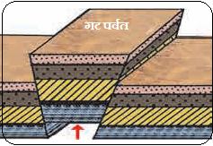
i) भूगर्भातील अंतर्गत ऊर्जा लहरींमुळे कठीण खडकांच्या थरांवर ताण निर्माण होऊन समांतर विभंग (Faults) किंवा प्रस्तरभंग पडतात.
ii) जेव्हा अंतर्गत बलामुळे दोन समांतर विभंगांमधील भूकवचाचा मधला भाग वर उचलला जातो, तेव्हा तो सपाट शिखराचा ठोकळ्यासारखा पर्वत बनतो, त्याला गटपर्वत म्हणतात.
iii) उदा. भारतातील सातपुडा पर्वत आणि युरोपमधील ब्लॅक फॉरेस्ट व व्हॉस्जेस पर्वत.
खचदरी (Rift Valley) :
i) दोन विभंगांच्या दरम्यानचा मधला भूभाग अंतर्गत ताणामुळे खाली खचतो, तेव्हा तिथे तीव्र उताराची खोल अरुंद दरी निर्माण होते, त्याला खचदरी म्हणतात.
ii) उदा. भारतातील नर्मदा व तापी नद्यांच्या दऱ्या आणि आफ्रिकेतील प्रसिद्ध खचदरी.

2) वळ्यांचे प्रकार(Types of Folds)
भूगर्भातील क्षितिजसमांतर हालचालींमुळे मऊ खडकांच्या थरांवर दोन्ही बाजूंनी दाब पडून खडकांना वळ्या पडतात (वलीकरण). खडकांचे स्वरूप आणि बलाची तीव्रता यानुसार वळ्यांचे खालील प्रकार पडतात :
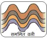
i) सममित वली: या वलीच्या दोन्ही बाजूंच्या भुजांचे कोन व उतार समान असतात, तसेच अक्षीय प्रतल उभे असते.
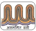
ii) असममित वली: या वलीच्या दोन्ही भुजांचे कोन व उतार असमान असतात. एक भुजा लहान व तीव्र उताराची असते.
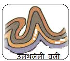
iii) उलथलेली वली: जेव्हा अंतर्गत दाब खूप जास्त असतो, तेव्हा वलीची एक भुजा दुसऱ्या भुजेवर झुकलेली दिसते.
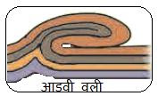
iv) आडवी वली: अंतर्गत दाब अतिशय तीव्र असल्यास वळ्या पूर्णपणे आडव्या (क्षितिजसमांतर) जमिनीवर पडतात.
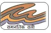
v) समनवत वली / समनतिक वली : या वलीच्या दोन्ही भुजा एकमेकांना आणि मुख्य अक्षीय प्रतलाला पूर्णपणे समांतर असतात.
3) भूकंप निर्मितीची कारणे
भूकवचातील खडकांच्या थरांत अंतर्गत हालचालींमुळे साठलेला प्रचंड ताण जेव्हा मर्यादेबाहेर जाऊन अचानक मोकळा होतो, तेव्हा भूकवच कंप पावते, ज्याला आपण भूकंप म्हणतो. भूकंपाची मुख्य कारणे खालीलप्रमाणे आहेत :
i) भूपट्ट हालचाली: पृथ्वीचे बाह्य कवच अनेक भूपट्टांचे बनलेले आहे. हे भूपट्ट जेव्हा एकमेकांवर आदळतात, एकमेकांपासून दूर जातात किंवा एकमेकांना घासून सरकतात, तेव्हा सीमावर्ती अस्थिर भागात तीव्र भूकंप होतात.
ii) ज्वालामुखी उद्रेक: तीव्र ज्वालामुखीच्या उद्रेकावेळी लाव्हा व प्रचंड दाबामुळे भूकवचाला हादरे बसतात व स्थानिक पातळीवर भूकंप घडून येतात.
iii) मानव निर्मित कारणे: मानवाचे अणुस्फोट, डोंगर तोडण्यासाठी केले जाणारे सुरुंगांचे स्फोट, मोठी खाणकामे आणि विस्तीर्ण धरणांच्या जलाशयांतील पाण्याचा भूगर्भावर पडणारा प्रचंड दाब यांमुळे कृत्रिम व स्थानिक भूकंप होऊ शकतात.
4) कार्बनन(Carbonation)
i) कार्बनल ही रासायनिक विदारणाची (Chemical Weathering) एक अत्यंत महत्त्वाची प्रक्रिया आहे. पावसाचे पाणी हवेतून जमिनीकडे येताना हवेतील कार्बन डायऑक्साइड (CO₂) वायू त्यात विरघळतो. या रासायनिक प्रक्रियेतून पाण्यात ‘सौम्य कार्बोनिक आम्ल’ (Carbonic Acid) तयार होते.
ii) चुनखडी (कॅल्शियम कार्बोनेट) सारख्या खडकांवरून जेव्हा हे आम्लयुक्त पाणी वाहते, तेव्हा त्यांची रासायनिक अभिक्रिया होऊन कॅल्शियम विरघळते आणि चुनखडीचे खडक विरघळून त्याचे वेगाने रासायनिक विघटन होते, या संपूर्ण प्रक्रियेला ‘कार्बनल’ म्हणतात.
अकरावी भूगोल नोट्स
XI Geography Unit Test 1
अकरावी भूगोल प्रथम घटक चाचणी

English medium question paper
Class : 11th
Subject : Geography
Time : 1.30 Hours
Total Marks : 25
XI Geography Unit Test 1
अकरावी भूगोल प्रथम घटक चाचणी
Question 1 (A) Complete the logical chain using the appropriate correlation from Groups A, B and C. (Marks : 4)
| Group A | Group B | Group C |
| 1. Igneous Rocks | Molecular Tension | Fire |
| 2. Granular Weathering | Earthquake | Heat |
| 3. Rapid Movement | Basalt | Block Mountain |
| 4. Slow Movement | Fault | Mechanical Weathering |
Question 1 (B) Identify the correct element. (Marks : 4)
1) Earthquake waves recorded beyond 140° —
A) Primary waves
B) Secondary waves
C) Surface waves
D) P and S waves
2) Ancient Fold Mountain —
A) Rocky
B) Aravalli
C) Himalaya
D) Vosges
3) Rock Fracture —
A) Elasticity of rocks
B) Pressure towards each other
C) Fold Mountain
D) Upward movement
4) Main type of rock —
A) Basalt
B) Igneous
C) Limestone
D) Slate
Question 2) Write geographical reasons for the following questions. (Any three) (Marks : 9)
- A crater lake is formed in a dead volcano.
- People living in the Himalayas are more vulnerable to earthquakes.
- Human beings are a factor of weathering.
- Slope is the main factor of mass wasting.
- Surface waves do not have an earthquake shadow zone.
Question 3) Write notes on any two of the following. (Marks : 8)
1) Block Mountain and Rift Valley
2) Types of Folds
3) Causes of Earthquake Formation
4) Carbonation
XI Geography Unit Test 1
अकरावी भूगोल प्रथम घटक चाचणी
Answer sheet in English medium
XI Geography Unit Test 1
अकरावी भूगोल प्रथम घटक चाचणी
Answer 1 (A)
| Group A | Group B | Group C |
| 1. Igneous Rocks | Basalt | Mechanical Weathering |
| 2. Granular Weathering | Molecular Tension | Heat |
| 3. Rapid Movement | Earthquake | Fire |
| 4. Slow Movement | Fault | Block Mountain |
Answer 1 (B) Identify the Correct Element
1) Earthquake waves recorded beyond 140° —
Answer : A) Primary waves
2) Ancient Fold Mountain —
Answer : B) Aravalli
3) Rock Fracture —
Answer : D) Upward movement
4) Main type of rock —
Answer : B) Igneous
XI Geography Unit Test 1
अकरावी भूगोल प्रथम घटक चाचणी
Answer 2) Geographical Reasons
1) A crater lake is formed in a dead volcano.
Answer :
i) A volcano that has not erupted again for a long period after an eruption is called a dead volcano.
ii) During a violent volcanic eruption, a very deep depression or crater is formed at the main vent of the volcano.
iii) Since there is no further eruption in the future, rainwater naturally accumulates in this deep depression and a beautiful lake is formed there, which is called a crater lake.
2) People living in the Himalayas are more vulnerable to earthquakes.
Answer :
i) The Himalayas are young fold mountains and were formed due to the movement and collision of the Indo-Australian and Eurasian plates towards each other.
ii) The Himalayas are located in a highly unstable geological zone along the boundary of these two active plates.
iii) Since internal movements and the process of disturbance of geostatic equilibrium are still continuing here, this region falls under a highly earthquake-prone area.
iv) Therefore, people living in the Himalayas are more vulnerable to the danger of earthquakes.
3) Human beings are a factor of weathering.
Answer :
i) Human beings carry out mining, construction of roads and railway transport routes, large dams, tunnels and buildings for their various developmental needs.
ii) For these activities, human beings use blasting, modern machines and technology, due to which hard rocks are rapidly broken and made loose.
iii) The weathering process that takes thousands of years in nature is brought about by human beings within a few days.
iv) Therefore, human beings are considered a major biological agent of weathering.
4) Slope is the main factor of mass wasting.
Answer :
i) Mass wasting and movements mainly occur on steep slopes in hilly and mountainous regions; they do not occur on flat plains.
ii) Due to the steepness of the slope, the gravitational force of the Earth becomes more effective and loose rocks, soil and mud are pulled downward.
iii) The steeper the slope, the greater the speed and intensity of soil erosion, landslides or mudflow.
iv) Movement is slow on gentle slopes; therefore, slope is the most important driving factor of mass wasting.
5) Surface waves do not have an earthquake shadow zone.
Answer :
i) Primary (P) and Secondary (S) earthquake waves travel through the interior and core of the Earth, due to which they undergo refraction in layers of different densities and the waves are not recorded in some areas; such an area is called an earthquake shadow zone.
ii) On the other hand, surface waves (L waves) do not travel through the interior of the Earth; they travel only along the Earth’s surface (crust) in a circular manner.
iii) Since there is no internal obstruction such as the core in their path, they do not undergo refraction; consequently, they do not have an earthquake shadow zone.
XI Geography Unit Test 1
अकरावी भूगोल प्रथम घटक चाचणी
Answer 3) Write Notes
1) Block Mountain and Rift Valley
Block Mountain :
i) Due to internal energy waves in the Earth’s interior, tension is created in layers of hard rocks, resulting in parallel faults or fractures.
ii) When the middle portion of the crust between two parallel faults is uplifted due to internal forces, it forms a block-like mountain with a flat summit, which is called a Block Mountain.
iii) Examples include the Satpura Mountains in India and the Black Forest and Vosges Mountains in Europe.
Rift Valley :
i) When the middle portion of the land between two faults subsides due to internal tension, a deep and narrow valley with steep slopes is formed, which is called a Rift Valley.
ii) Examples include the valleys of the Narmada and Tapi rivers in India and the famous Rift Valley of Africa.
2) Types of Folds
Due to horizontal movements within the Earth’s interior, pressure is exerted on both sides of soft rock layers, causing folds to form in the rocks (folding). According to the nature of the rocks and the intensity of the forces, the following types of folds are formed:
i) Symmetrical Fold : The limbs on both sides of this fold have equal angles and slopes, and the axial plane is vertical.
ii) Asymmetrical Fold : The angles and slopes of the two limbs of this fold are unequal. One limb is shorter and has a steeper slope.
iii) Overturned Fold : When the internal pressure is very high, one limb of the fold appears to be inclined over the other limb.
iv) Horizontal Fold : When the internal pressure is extremely intense, the folds lie completely horizontally (parallel to the horizontal plane) on the ground.
v) Isoclinal Fold : Both limbs of this fold are completely parallel to each other and to the main axial plane.
3) Causes of Earthquake Formation
When the enormous stress accumulated in the rock layers of the Earth’s crust due to internal movements exceeds the limit and is suddenly released, the crust vibrates, which we call an earthquake. The main causes of earthquakes are as follows:
i) Plate Movements : The outer crust of the Earth is made up of several plates. When these plates collide with each other, move away from each other, or slide past one another, intense earthquakes occur in unstable areas along their boundaries.
ii) Volcanic Eruption : During a violent volcanic eruption, lava and enormous pressure cause tremors in the Earth’s crust and earthquakes occur at the local level.
iii) Man-made Causes : Nuclear explosions, blasting carried out for cutting mountains, large-scale mining and the enormous pressure exerted by water in reservoirs of large dams on the Earth’s interior can cause artificial and local earthquakes.
4) Carbonation
i) Carbonation is a very important process of chemical weathering. As rainwater comes from the atmosphere towards the ground, carbon dioxide (CO₂) gas present in the air dissolves in it. Through this chemical process, ‘weak carbonic acid’ (Carbonic Acid) is formed in the water.
ii) When this acidic water flows over rocks such as limestone (calcium carbonate), a chemical reaction takes place in which calcium dissolves, and the limestone rocks dissolve and undergo rapid chemical decomposition; this entire process is called ‘Carbonation’.
XI Geography Unit Test 1
अकरावी भूगोल प्रथम घटक चाचणी